The vast expanse of the Pacific Ocean meets the sculpted shores of California, a dynamic interface that requires constant, meticulous understanding. For decades, the United States Navy has undertaken the critical task of surveying this intricate coastline, providing the foundational data that underpins everything from safe navigation to scientific research and resource management. These surveys are not mere cartographic exercises; they are the silent architects of maritime safety, the diligent chroniclers of an ever-changing underwater world, and an indispensable blueprint for the nation’s maritime interests.
The coastline of California is a complex tapestry woven with submerged hills, deep canyons, treacherous sandbars, and vital currents. For vessels of all sizes, from colossal container ships to small fishing boats, understanding the “lay of the land” beneath the waves is paramount. This is where the US Navy’s hydrographic surveys come into play, acting as the eyes that pierce the ocean’s surface, revealing the hidden topography essential for safe passage.
Navigational Safety: The Cornerstone of Hydrography
Imagine a sailor navigating at night, or in dense fog, relying solely on instruments and charts. Without accurate depth soundings, precise locations of known hazards like rocks and wrecks, and a detailed understanding of shorelines, the risk of grounding or collision escalates dramatically. The US Navy’s surveys provide this vital information, creating nautical charts that serve as the lifeblood of maritime navigation. These charts are not static documents; they are living records, continuously updated to reflect the dynamic nature of the coastal environment.
- Depth Soundings: The meticulous measurement of water depths at regular intervals forms the bedrock of any nautical chart. This data reveals the undulations of the seafloor, highlighting navigable channels and identifying areas of shallow water that pose a threat to vessels.
- Hazard Identification: The surveys diligently search for and precisely locate submerged obstacles, including shipwrecks, debris, and naturally occurring rocky outcrops. These are meticulously marked on charts to steer mariners clear.
- Shoreline Definition: While seemingly straightforward, accurately depicting the coastline, including features like cliffs, beaches, and tidal areas, is crucial for pilots and onshore operations.
Economic Implications of Accurate Mapping
Beyond immediate navigational safety, the economic ramifications of precise coastal mapping are profound. Ports and harbors are the gateways for global trade. Efficient and safe operations within these critical hubs depend directly on the quality of the underlying hydrographic data.
- Port and Harbor Management: Dredging operations, the construction of new piers and breakwaters, and the management of shipping lanes all rely on detailed bathymetric data. Accurate surveys ensure that these infrastructure projects are planned and executed effectively, minimizing costs and maximizing efficiency.
- Offshore Industries: The burgeoning offshore energy sector, including oil and gas exploration and the rapidly expanding wind farm industry, requires highly detailed seabed information. Surveys provide the data necessary for site selection, installation, and ongoing maintenance of these vital installations.
- Fisheries and Resource Management: Understanding the seafloor topography can also inform the management of marine resources. Certain fish species may favor particular types of seabed, and accurate mapping can aid in identifying and protecting critical habitats.
Scientific Understanding and Environmental Stewardship
The data collected by the US Navy’s surveys extends far beyond practical navigation. Scientists utilize this information to study a myriad of oceanographic phenomena, contributing to a deeper understanding of our planet’s most expansive ecosystem.
- Oceanographic Research: The detailed seafloor topography revealed by surveys provides a crucial backdrop for understanding ocean currents, sediment transport, and the geological evolution of the continental shelf.
- Marine Biology and Ecology: Researchers can correlate the physical seabed environment with the distribution of marine life, aiding in the study of species habitats and the impact of human activities on marine ecosystems.
- Coastal Zone Management: Understanding the intricate relationship between land and sea is vital for effective coastal zone management. Surveys provide data that informs decisions regarding coastal erosion, flood risk assessment, and the protection of sensitive coastal habitats.
Recent US Navy surveys of the California coast have provided valuable insights into underwater topography and marine ecosystems, which are crucial for both military operations and environmental conservation. For a more in-depth exploration of this topic, you can read the related article on naval strategies and their implications for coastal management at In The War Room.
The Tools and Technologies of Coastal Surveying
The US Navy employs a sophisticated suite of tools and technologies to achieve its meticulous mapping objectives. These instruments have evolved dramatically over time, from rudimentary lead lines to cutting-edge multibeam echosounders and satellite-based systems.
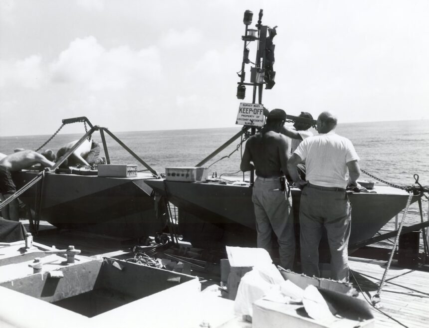
Hydrographic Survey Vessels: The Mobile Laboratories
The primary platforms for conducting these surveys are specialized hydrographic survey vessels. These ships are equipped with a range of sensors and data acquisition systems, serving as mobile laboratories that patrol the coastline.
- Hull-Mounted Echosounders: Traditional single-beam echosounders, mounted on the hull, provide depth measurements along the vessel’s track. While fundamental, they offer a limited view of the seafloor.
- Multibeam Echosounders: The Panoramic View: Modern survey vessels are equipped with advanced multibeam echosounders. These systems emit a fan-shaped array of sound beams, allowing for the simultaneous measurement of depths across a wide swath of the seafloor. This dramatically increases data acquisition efficiency and provides a much more comprehensive 3D representation of the seabed.
- Side-Scan Sonar: Imaging the Seabed’s Surface: Side-scan sonar systems emit acoustic pulses that reflect off the seafloor, creating images that reveal the texture and composition of the seabed. This is particularly useful for identifying submerged objects and geological features.
- Sub-Bottom Profilers: Peering Beneath the Surface: Sub-bottom profilers use lower-frequency acoustic waves to penetrate the seabed, revealing subsurface geological layers and identifying anomalies such as buried pipelines or ancient riverbeds.
Navigation and Positioning Systems: The Precision Anchors
Accurate positioning is as critical as accurate depth measurement. Without knowing precisely where a depth reading was taken, the data is rendered useless. The US Navy relies on highly sophisticated positioning systems.
- Global Navigation Satellite Systems (GNSS): Systems like GPS (Global Positioning System) provide precise latitude and longitude coordinates to the survey vessel. Differential GNSS (DGNSS) and Real-Time Kinematic (RTK) GNSS techniques further enhance accuracy to centimeter-level precision.
- Inertial Navigation Systems (INS): INS provides an independent means of tracking the vessel’s position, velocity, and orientation, particularly valuable in areas where GNSS signals may be weak or unavailable.
- Acoustic Positioning Systems: In shallower waters, acoustic transponders deployed on the seabed can be used in conjunction with onboard systems to provide highly accurate positioning of the survey vessel and any deployed equipment.
Data Processing and Quality Control: The Refiners of Raw Information
The sheer volume of data generated by modern survey operations is staggering. A significant effort is dedicated to processing this raw information and ensuring its accuracy and integrity.
- Real-Time Data Acquisition and Monitoring: Data is collected and initially processed in real-time onboard the survey vessel, allowing for immediate quality control and identification of any potential issues.
- Post-Processing and Calibration: More rigorous processing occurs after the survey is complete, involving the application of various corrections for tides, vessel motion, and sound velocity through the water column.
- Quality Assurance/Quality Control (QA/QC): Strict QA/QC procedures are implemented at every stage of the data lifecycle to ensure that the final products meet rigorous international standards.
The Survey Process: A Step-by-Step Expedition
Conducting a hydrographic survey is a methodical and carefully planned undertaking, akin to a precise surgical procedure performed on the ocean floor. Every step is designed to maximize data collection efficiency and ensure the highest level of accuracy.
Pre-Survey Planning: Laying the Groundwork
Before a single instrument is deployed or a vessel leaves port, extensive planning takes place. This phase is critical for defining the survey’s objectives and scope.
- Defining Survey Area and Objectives: The specific region to be surveyed is delineated, and the primary objectives are clearly defined. This could range from updating nautical charts in a busy shipping lane to investigating a potential site for offshore development.
- Chart Review and Existing Data Assessment: All available charting information and previous survey data are reviewed to identify areas that requireupdated or more detailed investigation. This avoids redundant effort and focuses resources where they are most needed.
- Resource Allocation and Vessel Assignment: The appropriate survey vessels, crew, and specialized equipment are assigned based on the survey’s requirements, considering factors like water depth, expected sea conditions, and the required level of detail.
Field Operations: The Eyes and Ears on the Water
This is the core phase where data is actively collected. It requires meticulous execution and constant vigilance.
- System Calibration and Testing: All survey equipment, from echosounders to positioning systems, undergoes rigorous calibration and testing before and during the survey to ensure accuracy.
- Executing Survey Lines: Survey vessels traverse specific, pre-determined track lines, systematically covering the entire survey area. The spacing of these lines is determined by the required level of detail.
- Data Logging and Monitoring: All sensor data is continuously logged, along with navigation and vessel motion information. Surveyors monitor the incoming data in real-time, looking for anomalies or areas that may require closer inspection.
- Investigating Anomalies: If the echosounder detects an unusual feature or if side-scan sonar reveals a potential hazard, the survey vessel will often conduct a more detailed investigation, sometimes using diver support or remotely operated vehicles (ROVs).
Post-Survey Analysis and Chart Production: Transforming Data into Usable Information
Once the field operations are complete, the vast amount of collected data is transformed into valuable maritime products.
- Data Cleaning and Correction: Raw data is meticulously cleaned to remove erroneous soundings or positioning outliers. Corrections are applied for tides, water density, and vessel attitude.
- Compilation and Modeling: The cleaned data is compiled to create a unified dataset. 3D models of the seafloor are often generated to visualize the bathymetry.
- Producing Nautical Charts and Data Products: The compiled and validated data is used to generate official US Navy nautical charts, digital data sets, and other specialized products for various end-users.
Evolution of Coastal Surveying: From Lead Lines to Autonomous Systems

The techniques employed by the US Navy for mapping the California coast have undergone a significant transformation throughout its history, mirroring advancements in technology and scientific understanding. This evolution has been a journey from rudimentary tools to highly sophisticated, often autonomous, systems.
Early Maritime Exploration: The Dawn of Charting
In the earliest days of maritime exploration, charting was a laborious and relatively imprecise undertaking.
- Lead Line Soundings: The primary method for measuring depth involved lowering a lead-weighted line overboard and reading the marked length when it reached the seabed. This provided discrete depth measurements only along the ship’s path.
- Visual Navigation and Celestial Fixes: Positions were determined through celestial observations and visual bearings to coastal landmarks, leading to a less precise positional accuracy compared to modern methods.
- Hand-Drawn Charts: Charts were painstakingly hand-drawn based on these limited measurements and observations, often with significant inaccuracies and gaps in coverage.
The Advent of Acoustic Technology: Seeing Beneath the Waves
The development of acoustic technology revolutionized hydrographic surveying, allowing for a more comprehensive and accurate understanding of the underwater environment.
- Single-Beam Echosounders: The introduction of single-beam echosounders provided a more efficient and accurate way to measure water depths along the vessel’s track. These systems emitted a single sound pulse and measured the time it took for the echo to return.
- Improvements in Positioning: Alongside acoustic advancements, the development of more precise navigation systems, such as Doppler sonar and radio navigation aids, improved positional accuracy significantly.
The Digital Revolution and Multibeam Sonar: High-Resolution Mapping
The latter half of the 20th century and the dawn of the 21st century have witnessed a digital revolution in hydrographic surveying, with multibeam sonar at its forefront.
- Multibeam Echosounders: This technology, as mentioned previously, provides a wide swath of bathymetric data, drastically increasing coverage and efficiency. It allows for the creation of highly detailed 3D models of the seafloor.
- Integrated Navigation and Data Acquisition Systems: Modern survey systems integrate navigation, positioning, and sonar data acquisition into a single, seamless digital workflow.
- Geographic Information Systems (GIS) and Data Management: The advent of GIS has enabled sophisticated management, analysis, and visualization of vast hydrographic datasets.
The Rise of Unmanned and Autonomous Systems: The Future of Surveying
In recent years, the US Navy has increasingly embraced unmanned and autonomous systems to augment their traditional survey capabilities.
- Unmanned Surface Vehicles (USVs): USVs, essentially remotely controlled or autonomous boats, can be deployed to conduct surveys in hazardous areas or to extend the survey coverage of larger vessels. They are often equipped with a suite of sensors, including multibeam echosounders and side-scan sonar.
- Unmanned Underwater Vehicles (UUVs): UUVs, or autonomous underwater vehicles (AUVs) as they are also known, can be programmed to survey specific areas independently, operating for extended periods without direct human control. They are particularly useful for surveying deep water or complex underwater environments.
- Swarm Robotics Concepts: Research is ongoing into the use of “swarms” of smaller, coordinated unmanned vehicles to conduct large-scale surveys more efficiently and cost-effectively.
The recent US Navy surveys of the California coast have sparked interest in understanding the environmental impacts and strategic importance of the region. For those looking to delve deeper into this topic, a related article discusses the implications of these surveys on both military operations and coastal ecosystems. You can read more about it in this insightful piece here.
Challenges and the Future of California’s Coastal Mapping
| Survey Year | Survey Area | Survey Type | Depth Range (meters) | Vessel Used | Purpose | Data Collected |
|---|---|---|---|---|---|---|
| 2018 | Monterey Bay | Hydrographic Survey | 0 – 200 | USNS Sumner | Navigation Safety | Bathymetry, Seafloor Mapping |
| 2019 | San Francisco Bay | Geophysical Survey | 0 – 150 | USNS Bowditch | Submarine Operations | Seafloor Sediment, Magnetic Data |
| 2020 | Santa Barbara Channel | Hydrographic Survey | 0 – 300 | USNS Bruce C. Heezen | Environmental Monitoring | Bathymetry, Water Column Data |
| 2021 | Point Reyes | Geophysical Survey | 0 – 100 | USNS Pathfinder | Seafloor Characterization | Seismic Profiles, Sediment Samples |
| 2022 | Channel Islands | Hydrographic Survey | 0 – 250 | USNS Maury | Navigation Safety | Bathymetry, Sonar Imaging |
Despite advancements, the task of mapping the California coast remains a dynamic challenge, influenced by both natural forces and evolving human needs. The ongoing efforts of the US Navy are crucial to adapting to these challenges and ensuring the continued availability of vital maritime information.
The Ever-Changing Seafloor: Dynamic Coastal Processes
The California coastline and its underlying seafloor are not static entities. Natural processes constantly reshape the underwater landscape.
- Sediment Transport and Erosion: Currents, wave action, and riverine input lead to continuous movement and deposition of sediment, altering the shape of the seafloor and potentially creating new hazards or filling in existing channels.
- Seismic Activity and Submarine Landslides: California is a seismically active region. Earthquakes can trigger submarine landslides, which can dramatically alter the seafloor topography and pose a significant risk to submerged infrastructure and navigation.
- Tectonic Plate Movement: The gradual movement of tectonic plates influences the long-term geological evolution of the coastline, requiring ongoing monitoring and eventual updates to bathymetric data.
Increasing Demands for Data: From Navigation to New Industries
As human activity in and around the coastal zone expands, so too does the demand for detailed and up-to-date hydrographic data.
- Offshore Renewable Energy Development: The push for offshore wind farms and other renewable energy sources necessitates highly detailed surveys for site assessment, installation, and environmental monitoring.
- Marine Protected Areas and Conservation Efforts: Understanding the seabed is crucial for effectively managing and monitoring marine protected areas and for supporting biodiversity conservation initiatives.
- Subsea Infrastructure: The installation and maintenance of telecommunications cables, pipelines, and other subsea infrastructure require precise bathymetric data for planning and safe operations.
The Role of Technology and Collaboration: Charting the Path Forward
The future of coastal mapping for California, and indeed for coastlines worldwide, lies in the continued development and application of advanced technologies, coupled with strong collaborative partnerships.
- Continued Advancement of Unmanned Systems: The increasing sophistication of USVs and UUVs will likely lead to more cost-effective and efficient survey operations, enabling broader coverage and more frequent updates.
- Integration of Multi-Sensor Platforms: Combining data from various sensors, including sonar, lidar, and satellite imagery, can provide a more comprehensive and nuanced understanding of the coastal environment.
- Data Sharing and Interoperability: Fostering greater data sharing and ensuring interoperability between different data sets and platforms is essential for maximizing the value of hydrographic information.
- Partnerships with Academia and Industry: Collaboration between the US Navy, academic institutions, and private industry can accelerate innovation and ensure that survey capabilities meet the evolving needs of society.
The US Navy’s commitment to mapping the California coast is a testament to the enduring importance of accurate maritime data. These surveys are not just lines on a chart; they are the silent guardians of safe passage, the essential guides for economic development, and the fundamental bedrock for understanding and protecting our vital marine environment. As technology advances and the demands upon our oceans grow, the meticulous work of hydrographic surveyors will continue to be an indispensable endeavor, ensuring that the gateway to California’s maritime future remains clearly and precisely charted for all.
FAQs
What is the purpose of the US Navy surveys of the California coast?
The US Navy surveys of the California coast are conducted to map and chart coastal waters for safe navigation, support military operations, and assist in coastal management and environmental protection.
When did the US Navy begin surveying the California coast?
The US Navy began systematic surveys of the California coast in the mid-19th century, particularly after California became a state in 1850, to improve maritime safety and support naval activities.
What methods are used in the US Navy surveys of the California coast?
The surveys typically use hydrographic techniques including sonar mapping, depth sounding, aerial reconnaissance, and satellite imagery to collect detailed data on underwater topography and coastal features.
How do the US Navy surveys benefit civilian maritime activities?
The surveys provide accurate nautical charts and data that help commercial shipping, fishing, and recreational boating navigate safely, reducing the risk of accidents and environmental damage.
Are the results of the US Navy surveys publicly available?
Yes, many of the survey results are shared with the National Oceanic and Atmospheric Administration (NOAA) and other agencies, and are made available to the public through nautical charts and online databases.