
Arctic bases serve as critical outposts in one of the most remote and inhospitable regions of the world. These installations, often established by various nations, play a pivotal role in military strategy, scientific research, and environmental monitoring. The harsh conditions of the Arctic, characterized by extreme cold, ice-covered landscapes, and prolonged periods of darkness, make these bases unique in their operational requirements and challenges.
As global interest in the Arctic intensifies due to climate change and geopolitical tensions, understanding the significance of these bases becomes increasingly important. The strategic positioning of Arctic bases allows for enhanced surveillance and control over vast territories that are often difficult to access. They serve not only as military installations but also as hubs for scientific research aimed at understanding climate change, wildlife conservation, and the effects of human activity on fragile ecosystems.
The presence of these bases highlights the intersection of national security interests and environmental stewardship, making them focal points in discussions about the future of the Arctic region.
Key Takeaways
- Arctic bases have strategic military, scientific, and economic significance in the polar region.
- Satellite imagery plays a crucial role in uncovering and monitoring remote Arctic outposts.
- These bases face environmental challenges and impact the fragile Arctic ecosystem.
- Personnel at Arctic bases encounter extreme conditions and logistical difficulties.
- The future of Arctic bases is shaped by international relations and evolving geopolitical interests.
History of Arctic Bases
The history of Arctic bases is deeply intertwined with the exploration and militarization of the polar regions. The early 20th century marked the beginning of significant interest in the Arctic, driven by both scientific curiosity and national ambitions. Countries like Norway, Canada, and the United States established their first bases during this period, primarily for exploration and research purposes.
The onset of World War II further accelerated the establishment of military bases in the Arctic as nations sought to secure their interests in this strategically vital area. Post-war developments saw an expansion of Arctic bases, particularly during the Cold War era. The United States and the Soviet Union recognized the importance of Arctic territories for military operations and surveillance.
This led to the construction of numerous bases equipped with advanced technology for monitoring enemy movements and conducting reconnaissance missions. The legacy of these early installations continues to influence contemporary Arctic policy and military strategy, as nations vie for dominance in a region that is becoming increasingly accessible due to climate change.
Importance of Satellite Imagery in Revealing Remote Outposts
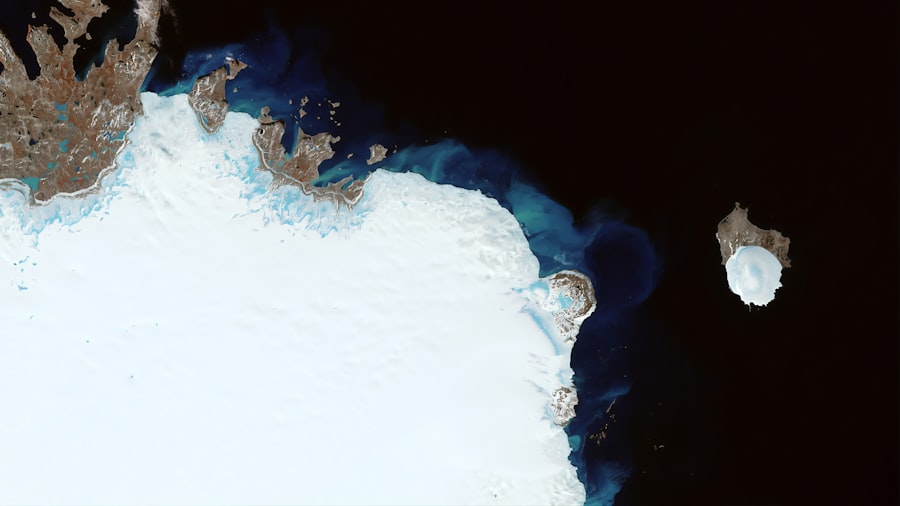
In recent years, satellite imagery has emerged as a powerful tool for monitoring Arctic bases and understanding their implications on a global scale. The ability to capture high-resolution images from space allows researchers and analysts to observe changes in infrastructure, troop movements, and environmental conditions without needing to physically access these remote locations. This technology has revolutionized how nations assess their interests in the Arctic, providing a clearer picture of activities that may otherwise remain hidden beneath layers of ice and snow.
The significance of satellite imagery extends beyond mere observation; it also plays a crucial role in fostering transparency and accountability among nations operating in the Arctic. By making satellite data publicly available, organizations can promote dialogue and cooperation among Arctic states, reducing the potential for misunderstandings or conflicts over territorial claims. Furthermore, satellite imagery aids in tracking environmental changes resulting from human activity, thereby contributing to efforts aimed at preserving the fragile Arctic ecosystem.
Key Findings from Satellite Imagery
Recent analyses utilizing satellite imagery have revealed a wealth of information about the state of Arctic bases and their activities. For instance, researchers have documented significant expansions in infrastructure at various military installations, indicating a heightened focus on military readiness in the region. New runways, radar systems, and housing facilities have been observed, suggesting that nations are investing heavily in their Arctic capabilities.
This expansion reflects not only military interests but also a response to changing geopolitical dynamics as more countries seek to assert their presence in the Arctic. Moreover, satellite imagery has uncovered patterns related to environmental changes linked to these bases. Melting ice caps and shifting wildlife habitats have been documented alongside military activities, raising concerns about the ecological impact of increased human presence in this sensitive area.
The juxtaposition of military expansion with environmental degradation highlights the complex challenges faced by policymakers who must balance national security needs with environmental stewardship.
Role of Arctic Bases in Military Operations
| Arctic Base | Location (Latitude, Longitude) | Satellite Imagery Resolution | Last Image Capture Date | Base Size (sq km) | Operational Status | Notable Features |
|---|---|---|---|---|---|---|
| Barneo Ice Camp | 89.0°N, 30.0°E | 0.5 m | 2024-05-15 | 0.02 | Seasonal | Temporary ice runway, research station |
| Ny-Ålesund Research Station | 78.9°N, 11.9°E | 1 m | 2024-06-01 | 0.1 | Permanent | Scientific research, satellite calibration |
| Alert Station | 82.5°N, 62.3°W | 0.3 m | 2024-05-28 | 0.05 | Permanent | Military and weather monitoring |
| Thule Air Base | 76.5°N, 68.7°W | 0.5 m | 2024-05-30 | 0.3 | Permanent | US Air Force base, satellite tracking |
| Rothera Research Station | 67.6°S, 68.1°W | 1 m | 2024-05-20 | 0.15 | Permanent | Antarctic research, logistics hub |
Arctic bases play a crucial role in shaping military operations within the region. Their strategic locations allow for rapid deployment of forces and resources in response to emerging threats or crises. As nations recognize the importance of maintaining a robust military presence in the Arctic, these bases become essential for conducting training exercises, surveillance missions, and logistical support operations.
The ability to operate effectively in extreme conditions is paramount, necessitating specialized equipment and training for personnel stationed at these outposts. Furthermore, Arctic bases serve as critical nodes in broader military networks that extend beyond national borders. They facilitate cooperation among allied nations through joint exercises and information sharing, enhancing collective security efforts in an increasingly contested environment.
As tensions rise over territorial claims and resource competition, the role of these bases in military strategy will likely continue to evolve, reflecting changing geopolitical realities.
Environmental Impact of Arctic Bases
The establishment and operation of Arctic bases inevitably come with significant environmental consequences.
Fuel spills, waste disposal issues, and increased human activity pose threats to fragile wildlife populations that rely on the Arctic environment for survival.
As climate change accelerates, these impacts may be exacerbated by shifting weather patterns and melting ice. Efforts to mitigate environmental damage are becoming increasingly important as awareness grows regarding the delicate balance between military operations and ecological preservation. Some nations are implementing stricter regulations on waste management and resource use at their Arctic bases to minimize their footprint.
However, challenges remain in enforcing these measures consistently across different jurisdictions, highlighting the need for international cooperation in addressing environmental concerns associated with Arctic activities.
Challenges Faced by Personnel at Arctic Bases
Personnel stationed at Arctic bases encounter a unique set of challenges that test their resilience and adaptability. The extreme weather conditions—characterized by frigid temperatures, strong winds, and limited daylight—demand specialized training and equipment to ensure safety and operational effectiveness. Isolation from family and friends can also take a psychological toll on service members, necessitating robust support systems to help them cope with the demands of life in such a remote environment.
Additionally, logistical challenges complicate daily operations at these bases. Supply chains can be disrupted by harsh weather or ice conditions, making it difficult to obtain essential resources such as food, fuel, and medical supplies. This unpredictability requires personnel to be resourceful and prepared for contingencies that may arise during their deployment.
As nations continue to invest in their Arctic capabilities, addressing these challenges will be crucial for maintaining morale and operational readiness among those stationed at these outposts.
Future of Arctic Bases
The future of Arctic bases is likely to be shaped by a combination of geopolitical dynamics, environmental considerations, and technological advancements. As climate change continues to alter the landscape of the Arctic region—making it more accessible for shipping routes and resource extraction—nations may feel compelled to enhance their presence further. This could lead to an arms race in terms of infrastructure development as countries seek to secure their interests amid growing competition.
At the same time, there is an increasing recognition of the need for sustainable practices within these bases. Future developments may prioritize eco-friendly technologies and practices that minimize environmental impact while still meeting operational requirements. Collaborative efforts among Arctic nations could pave the way for shared standards regarding environmental protection and resource management, fostering a more cooperative approach to governance in this sensitive region.
International Relations and Arctic Bases
The presence of Arctic bases has significant implications for international relations among countries with interests in the region. As nations assert their claims over territorial waters and resources, tensions can arise that threaten stability in an already fragile geopolitical landscape. Diplomatic efforts are essential for managing these disputes and fostering cooperation among Arctic states.
Forums such as the Arctic Council provide platforms for dialogue aimed at addressing shared challenges while promoting peaceful coexistence. Moreover, international relations are influenced by perceptions surrounding military activities at these bases. Transparency regarding operations can help build trust among nations; however, secrecy or aggressive posturing can lead to misunderstandings that escalate tensions.
As global interest in the Arctic continues to grow, maintaining open lines of communication will be vital for ensuring that competition does not devolve into conflict.
Economic and Scientific Activities at Arctic Bases
Beyond their military significance, Arctic bases also serve as centers for economic and scientific activities that contribute to our understanding of this unique environment. Research conducted at these outposts focuses on climate change impacts, biodiversity conservation, and sustainable resource management—areas critical for informing policy decisions both regionally and globally. Collaborations between military personnel and scientists can yield valuable insights into how human activity interacts with natural systems.
Economic activities associated with Arctic bases often revolve around resource extraction—such as oil drilling or mineral mining—which can generate revenue but also raise ethical questions regarding environmental stewardship. Balancing economic interests with ecological preservation remains a contentious issue among stakeholders involved in decision-making processes related to Arctic development.
Implications of Revealing Remote Outposts
The revelation of remote outposts through satellite imagery has profound implications for understanding the dynamics at play within the Arctic region. As nations expand their presence through military installations while grappling with environmental challenges posed by climate change, it becomes increasingly important to foster dialogue among stakeholders involved in shaping policies governing this sensitive area. The intersection between national security interests and ecological preservation underscores the complexity inherent in managing competing priorities.
Ultimately, addressing these challenges requires collaborative efforts that transcend national boundaries—recognizing that the future of the Arctic is interconnected with global well-being. By promoting transparency through technologies like satellite imagery while prioritizing sustainable practices at Arctic bases, stakeholders can work towards a more harmonious coexistence that respects both security needs and environmental integrity in one of Earth’s last frontiers.
Satellite imagery has become an invaluable tool for monitoring Arctic bases, providing insights into military activities and environmental changes in this remote region. For a deeper understanding of the implications of such surveillance, you can read a related article on the topic at this link. This article explores the strategic importance of Arctic bases and how satellite technology is reshaping our understanding of geopolitical dynamics in the area.
WATCH THIS! 🎬 America’s Nuclear City Was a Lie: The Russian Base That Made Iceworm Obsolete
FAQs
What is satellite imagery?
Satellite imagery refers to images of Earth or other planets collected by imaging satellites operated by governments and businesses around the world. These images are used for various purposes including environmental monitoring, mapping, and surveillance.
Why is satellite imagery important for Arctic bases?
Satellite imagery is crucial for Arctic bases because it provides real-time and historical data on environmental conditions, ice coverage, and infrastructure status. This helps in planning logistics, monitoring climate change effects, and ensuring the safety and operational efficiency of the bases.
What types of satellites are used to capture images of Arctic bases?
Both optical and radar satellites are used to capture images of Arctic bases. Optical satellites provide high-resolution images in visible light, while radar satellites can capture images regardless of weather conditions or darkness, which is especially useful in the Arctic’s extreme environment.
How often is satellite imagery updated for Arctic regions?
The frequency of updates depends on the satellite system. Some satellites can provide daily or even multiple images per day, while others may have longer intervals. Continuous monitoring is often necessary due to the dynamic and harsh conditions in the Arctic.
Can satellite imagery detect changes in Arctic base infrastructure?
Yes, satellite imagery can detect changes such as construction, damage, or expansion of Arctic base infrastructure. By comparing images over time, analysts can assess the development and maintenance status of these facilities.
Are there any challenges in using satellite imagery for Arctic bases?
Challenges include extreme weather conditions, polar night (extended darkness), and ice cover, which can affect image quality and frequency. Additionally, the remote location can limit the availability of high-resolution images and complicate data interpretation.
Who uses satellite imagery of Arctic bases?
Users include government agencies, military organizations, scientific researchers, environmental monitoring groups, and commercial entities interested in Arctic operations, climate studies, and resource exploration.
Is satellite imagery of Arctic bases publicly available?
Some satellite imagery is publicly available through platforms like NASA, ESA, and commercial providers, but high-resolution or sensitive images related to military or strategic bases may be restricted or classified.
How does satellite imagery contribute to understanding climate change in the Arctic?
Satellite imagery helps track changes in ice cover, permafrost, and environmental conditions around Arctic bases, providing valuable data to study the impacts of climate change and to develop mitigation and adaptation strategies.
What advancements are improving satellite imagery of Arctic bases?
Advancements include higher resolution sensors, improved radar imaging, increased satellite constellations for more frequent coverage, and enhanced data processing techniques such as AI and machine learning for better analysis and interpretation.